Showing posts with label Montana. Show all posts

Tuesday, May 25, 2010

Summer 2010 Restoration Around the Clark Fork Basin

Butte

While the EPA Five-Year Review of Butte Superfund sites continues, reclamation and restoration work is still ongoing in the area. At the top of the Butte hill near Walkerville construction will be completed in 2010 on the Granite Mountain Memorial Interpretive Area. The Memorial itself is being expanded, and an already partially-completed trail will connect that area to the greater uptown Butte trail system. This new trail will provide the public with access to the historic Foreman’s Park near the Mountain Con mine yard.

Monitoring of stormwater and groundwater is also ongoing to insure that metals and other mining contaminants from the Butte hill do not recontaminate the restored Silver Bow Creek. New groundwater monitoring wells are being installed near the historic Silver Bow Creek channel, commonly known as the Metro Storm Drain, and also in Lower Area One on the west side of the Butte, where treatment lagoons capture contaminated groundwater and surface water to prevent contamination from reaching Silver Bow Creek.

Beyond 2010 the Metro Storm Drain and Lower Area One treatment lagoons will be evaluated; best management practices for stormwater will be implemented; the Butte Reclamation Evaluation System will continue to monitor capped mine dumps on the Butte hill to ensure that historic mine wastes are not spreading; and the voluntary Residential Metals Abatement Program will continue to assist residents in assessing and removing historic wastes present in Butte homes.

Work also continues on the restoration of Silver Bow Creek. Through the summer, crews are removing mine waste and restoring the creek through Durant Canyon and near Fairmont Hot Springs.
Above: A restored reach of Silver Bow Creek near Butte shows a developing riparian plant community.
Above: An unrestored reach of Silver Bow Creek near Anaconda has little vegetation along the streambank due to the presence of mine tailings; these acid and heavy metal-laden soils prevent most plants from growing. This reach is slated for restoration in the next 1-2 years.

Anaconda

A lot of clean-up is underway in Anaconda, including reclamation north of Warm Springs Creek near the Galen Highway; clean-up of the Airport property; and Montana DEQ will begin reclamation on Stucky Ridge. Clean-up also continues along rail lines and rail yards.

In 2010, EPA will begin the fourth Five-Year Review of the Anaconda Smelter site. Reviews address portions of the site where remedial construction has been completed and where EPA has determined the remedy is operational and functional.

Next door at Opportunity, management continues at the BP-Arco Waste Repository.
The site, formerly the Opportunity Ponds, was a tailings repository for the Anaconda Smelter. It covers an area of over five square miles, with deposits of mine waste averaging about 20 feet deep. Due to that considerable volume of contamination, wastes removed from elsewhere in the Clark Fork Basin are transported to the Opportunity Ponds site. Topsoils are then revegetated to reduce erosion.

During the five-year review of Anaconda sites, EPA and DEQ welcome public comments regarding Anaconda-area work, and comments may help to determine recommendations for the future. Citizens may send written comments through May 28 to:

Charlie Coleman
Remedial Project Manager
10 West 15th Street, Suite 3200
Helena, MT 59626; or

John Brown
Superfund Project Officer
P.O. Box 200901
Helena, MT 59620-0901.

Milltown Area


At the confluence of the Blackfoot and Clark Fork Rivers, the last trainload of contaminated sediments left the Milltown site on September 24, 2009. Work still continues at the site to restore the historic stream channel. The Clark Fork River is currently diverted until that work can be completed. Once that work is done, restoration of the greater confluence site will begin.

The Clark Fork River Technical Assistance Committee (CFRTAC) has a wealth of additional information on their website at http://www.cfrtac.org/.

Checking In with Clark Fork Ecosystems
and Spring Field Season Photos

CFWEP’s spring field season started off cold and windy, but things have been warming nicely. So far, CFWEP has collected field data with four Butte area schools: Butte Central, Fred Moodry Middle School, Ramsay Middle School, and East Middle School.

Fred Moodry Middle School sampled water chemistry, vegetation, macroinvertebrates and soil from Silver Bow Creek near Anaconda (a mining-impacted site) and from the unimpacted Warm Springs Creek in Anaconda. The students findings were striking. For example, the conductivity at the impacted site was twice as high as the unimpacted site, indicating that there were more dissolved particles at that location on Silver Bow Creek. Both sites had a high diversity of macroinvertebrates, but only unimpacted Warm Springs Creek had stonefly and mayfly larvae, which are the most sensitive indicators of healthy streams. The students found a high diversity of vegetation at the unimpacted site, with a healthy mix of ground cover, understory and over story, while the impacated site vegetation habitat consisted of tailings, bare ground and pollution tolerant plants. All of the students clearly enjoyed their field trips, and kudos to them for braving sometimes wet, windy, cold conditions to do science.

Below are photos from various winter-spring 2010 field trips and education projects.

Butte students help to improve the Butte stormwater system that discharges into Silver Bow Creek.


Students visit the Kalsta Ranch on the Big Hole River on a recent field trip.


Students from Bonner visit the Berkeley Pit as part of a field trip to Butte.


Anaconda students visit the BP-Arco Waste Repository, formerly known as the Opportunity Ponds.

Bulltrout, The Blackfoot River & Milltown

While the last sediments contaminated by historic mine waste were shipped by rail away from the former Milltown Dam site at the confluence of the Clark Fork and Blackfoot Rivers near the end of 2009, much work remains to be done at the site. There are still roughly 4 million cubic yards of mining contaminated sediments left behind at the site. These additional contaminants were left because the removal of the dam and saturate sediments left them high and dry, where likelihood of them ever becoming entrained in the river or contaminating the groundwater is slim to nothing.

An April 11 article in The Missoulian described the concerns of some local residents regarding the impact on native bull trout from work at the site. Concerns for bull trout stem from work on the piers that support the Interstate 90 overpass over the Blackfoot, just before it joins with the Clark Fork. The Clark Fork River is currently diverted into a side channel running near I-90 while crews continue reclamation and restoration of the natural stream channel. This situation has caused the Blackfoot, as it flows under I-90, to narrow, and water velocity speeds up as a result. Some Bonner residents are concerned that this will make it difficult for bull trout to navigate.


Above: The diverted Clark Fork River now flows through an artificial channel near I-90 while crews continue to restore the historic floodplain and river channel.

Bull trout were listed as a threatened species by the U.S. Fish and Wildlife Service in 1998. The bulls are a sensitive species that do not tolerate high sediment levels in their spawning streams. Many Upper Clark Fork tributaries are considered spawning streams for bulls. The Fish and Wildlife Service is currently considering a proposal to increase the amount of land considered critical habitat for bull trout, noting that “Bull trout depend on cold, clear water and are excellent indicators of water quality. Protecting and restoring their habitat contributes to the water quality of rivers and lakes throughout the Northwest.”

Pat Saffel, Montana Fish, Wildlife and Parks (FWP) fisheries manager for the region, has said that no immediate action is necessary. Fish passage at the overpass is typically only an issue during short periods of high flow. When the water level comes back down, the fish can navigate the narrow, rapid channel. The EPA is currently reviewing the issue, and FWP is monitoring fish populations in the area to better understand the effects of the removal of the Milltown Dam.

Short-term impacts related to the reclamation and restoration of the old reservoir site may harm fish, but the long-term effects of the dam removal are likely to be very beneficial to the fishery, outweighing the short-term negatives. More remedial and redevelopment work remain in the Milltown cleanup project, which is expected to end in 2011. Once all is said and done, the connectivity of the Clark Fork Basin will be greatly improved, giving native fish like the bull and cutthroat trout increased opportunities to find suitable habitat and spawning grounds in the numerous Upper Clark Fork tributary streams and creeks.

Spring 2010 CFWEP Acknowledgments

CFWEP would like to acknowledge the following new members, volunteers and contributors. Their support and assistance makes our work possible:
Kathryn Watson & the Montana Watercourse; Jenny Wilson; Janel Evans; Chris Doyle; Karen Gillespie; Dina Alibrahim; Joe Griffin (DEQ); Doug Martin (NRDP); Kathy Coleman (NRDP); Colleen Elliott (MBMG); Andrea & Don Stierle; Gary Swant; Samantha Sheble; Lisa Sullivan; Lori Shyba; Sandra McNair; Rick Larson, Jack Henry, Tawni Cleverly, Doug Sanderson, Nate Gelling & Butte-Silver Bow County; Marisa Pedulla; Michelle Anderson; Angela Smith & the Washoe Fish Hatchery; Jeanne Larson; Jeremy Weber; Theresa Rader; Montana Environmental Education Association; Marilyn and Bob Olson (Embroidery Plus); Digger Athletic Association; Montana Tech Foundation; George Goody (Montana Fly Company); Chris Bradley & Mike Marcum (The Stonefly Fly Shop); Bill Callaghan; Misty Cerise Cunningham; Chris Kellogg; Mike Bader; Kristina Smucker; Rich Prodgers (Bighorn Environmental); Tim Reilly (DEQ); Jeremey Whitlock; Carlton Nelson; Meriwether Ranch; Wallace J. Nichols (bluemarbles.org); Dick Berg and John Foley (MBMG/Mineral Museum); Almetek Industries; Marko Lucich (Butte Chamber); City of Deer Lodge and Powell County; Jason Smith (Grant Kohrs Ranch); Holiday Inn Express (Butte); George Grant TU; Keri Petritz; Beverly Plumb; Atlas Obscura; Ken Brockman (Bureau of Reclamation); Atlantic Richfield Corporation; Erik Kalsta and Jami Murdoch; Tucker Transportation; Debbie Kearns (The Hitchin’ Post in Melrose); Michelle Anderson; Ray Brandl; Chad Buck; Pat Cunneen (NRDP); Chris Gammons; Jim Gleason (TU); Doug Joppa; Raj Kasanath; Byron Mazurek; Abbie Philips; Sara Rouse; Christine Talley; Shane Talley; Karen Wesenberg-Ward; and all those who helped out with field trips, classroom activities, teacher workshops, and events in winter and spring 2010!


Above: A long-billed curlew flies over the BP-Arco Waste Repository, formerly the Opportunity Ponds, near Anaconda.

Tuesday, February 23, 2010

Milltown, Montana: Film Creates a Cultural Portrait of Western Montana

If a picture is worth a thousand words, a moving picture must be worth considerably more. Judging by his latest work, I believe Rainer Komers must have taken that old adage to heart. His film Milltown, Montana takes the motion picture genre on a journey of “poetic minimalism”. What this meant became clear to me when I spoke with Rainer prior to the screening, and he mentioned that the film had no dialogue and no score. Considering my minimal exposure to "avant-garde" film, I couldn't help but be skeptical. The screening at Montana Tech attracted an audience of about 50 people, quite a few more than I was expecting.

What I noticed as I watched the film is how little I missed the traditional narration and accompanying soundtrack. Komers captures these “acoustic soundscapes” to go along with the visuals, which are greatly enhanced by his considerable acumen behind the camera thanks to his years of experience as a cinematographer. The sounds are vivid enough to capture your attention, with an abstract musicality that can be hypnotizing at times.

I found that the absence of a narrator allowed the viewer to become an impartial observer, free to draw their own conclusions as to the meaning of what they were seeing. Some of the sights I recognized throughout the film were shots of the M&M sign, The Legion Oasis, the Clark Fork Watershed, the State Prison and various snapshots of everyday life in the region. There was a billiards scene in the Legion that garnered quite a few laughs, an injection of humor I wasn't quite expecting.

In another review of the film in the Missoulian, the author seemed very upset that the film did not tell the story of Milltown in particular. As Komers explained to the audience during the Q&A session, the title is meant to be generic, to describe any region that has been through the growing pains of the industrial age. He explained this by relating a tale of coal mining in his native Germany, where the towns have similar problems with pollution and mining. My personal interpretation was that the film seemed like it was intended to be a snapshot in time, a cultural portrait with minimal bias. The film was only 30 minutes long, but managed to capture the essence of many aspects of life in Montana in that short time.

The region around Butte has the distinct privilege of having two films made about it in a short period of time. Milltown, Montana may not have the historical scope of the much acclaimed Butte, America, but it offers a more intimate portrayal of everyday life in post-industrial Montana. The two films compliment each other, one telling the story of the past, the other showing how residents deal with the repercussions of that past, from an outsiders perspective. Komers has a talent for being the outside observer, presenting a way of life without the usual editorial spin. I would consider Montana lucky to be included in his impressive body of work.

For a complete listing of Komers film work, visit: http://www.imdb.com/name/nm0464624/

-Guest Blog by Aaron Briggs
Montana Tech Professional & Technical Communications Student

Monday, February 22, 2010

U.S. Fish and Wildlife Service Examines Bull Trout Habitat

The bull trout is one of Montana’s most unique fish. They can grow to over three feet and can weigh over 20 pounds, and depend on cold, clear water. Bull trout are excellent indicators of water quality, and are often considered an “umbrella” species. That is, if water quality is healthy enough for bull trout, it is likely healthy enough for most other, less-sensitive aquatic species native to Montana. Their sensitivity to adverse water conditions, coupled with the competition posed by non-native fish such as the brook trout, have caused bull trout numbers to slowly decline across the northwest, and they were listed as a threatened species under the Endangered Species Act (ESA) in 1998.


On January 13, the U.S. Fish and Wildlife Service proposed to revise its 2005 designation of critical habitat for the bull trout. Under the ESA, critical habitat identifies geographic areas essential for the conservation of a listed species. Critical habitat designations provide extra regulatory protection to areas that may require special management considerations, and the habitats are then prioritized for recovery actions. The critical habitat designation does not affect land ownership, does not allow government or public access to private lands, and does not impose restrictions on non-federal lands unless federal funds, permits or activities are involved. However, it alerts landowners that these areas are important to the recovery of the species. In the Clark Fork Basin, as restoration continues on mining-impacted ecosystems, maintaining quality bull trout habitat can be seen as a final hurdle; if bull trout return to some of the historically damaged areas of the Clark Fork watershed, then we can safely assume that restoration efforts are succeeding.

In total, the Service proposes to designate approximately 22,679 miles of streams and 533,426 acres of lakes and reservoirs in Idaho, Oregon, Washington, Montana and Nevada as critical habitat for the wide-ranging bull trout. The proposed revision comes after extensive review of earlier critical habitat proposals and public comments. The Service voluntarily embarked on this re-examination to ensure that the best science was used to identify the features and areas essential to the conservation of the species.

In Montana, additional bull trout critical habitat is proposed for the Kootenai, Clark Fork and St. Mary River Basins. Under the 2010 proposal, most tributaries of the Blackfoot River, Flint Creek and the Clark Fork River would be considered critical bull trout habitat. Most of the Blackfoot, as well as sections of Flint Creek and the Clark Fork, were previously designated as critical bull trout habitat in 2005.

The Clark Fork and Flathead watersheds were historically important to bull trout prior to the heavy impacts caused by human developments such as hydroelectric dams, other manmade barriers, and historic mining. Today, those river systems are being reconnected through dam removal (Milltown Dam), improved fish passage (Cabinet Gorge, Noxon Rapids, Thompson Falls), and improved habitat (Clark Fork restoration projects). The Clark Fork River is particularly important, as it provides a migratory corridor for bull trout from Lake Pend Oreille and the lower river to access the Blackfoot, Rock Creek, and potentially Flint and Warm Springs Creeks, where significant populations of bull trout remain.

To do our part to help bull trout recover, anyone fishing in western Montana should repeat the mantra: No Black, Put It Back! Bull trout are most easily distinguished from other Montana trout by their top fin; unlike other trout, the bull trout have no black spots on their top fin. They are also characterized by a slightly forked tail and pale yellow, orange and red spots on the body. As a threatened species, bull trout should be released immediately if caught. To assist in identifying Montana trout, CFWEP, Montana Fish Wildlife & Parks, the Sierra Club, and the University of Montana distribute free pocket fish ID guides. Contact CFWEP for your free guide before heading out on the river.

The Service will accept public comments on the proposed critical habitat until March 15, 2010. For information on how to submit a public comment, and for more on the proposed critical habitat designation, visit www.fws.gov/pacific/bulltrout. For a direct link to a map comparing existing bull trout critical habitat with proposed 2010 habitat, click here. You can learn more about bull trout in Montana at the Montana Field Guide from mt.gov.


The above map shows bull trout range in Montana.

The above map shows bull trout density in Montana.

Wednesday, February 10, 2010

Volunteers Needed for 2010 Spring Field Season

CFWEP is seeking volunteers for spring field trips running from March 2 through June 1, 2010. Volunteers provide support on field trips with middle and high school students and teachers. Volunteering requires no previous experience (CFWEP will provide field science training), it is a great way to learn about the Montana outdoors and the restoration of the Clark Fork Basin, and you will be helping future generations to become stewards of western Montana's amazing environment.

For a complete list of spring volunteer opportunities, click here to view the full schedule (MS Excel format). To register as a volunteer, or to learn more, contact CFWEP Field Coordinator Dr. Arlene Alvarado at aalvarado@mtech.edu or call (406) 496-4862.

Monday, November 23, 2009

Mining the Highlands


While Montana’s wide-open mountain vistas, relatively undisturbed wildlife habitat and peaceful, windy quietude have risen among the top of the state’s golden treasures, there is still plenty of interest in the kind of gold currently fetching over $1,000 per ounce on the worldwide metals market. Just 15 miles south of Butte in the heart of the Highlands Mountains, Timberline Resources is making way for a new, 750,000+ ounce underground gold mine. The Idaho-based newcomer to the mining industry began laying the groundwork in August for what the corporation hopes to be a 10-year project that could employ up to 100 workers. Timberline stock (TLR) began trading on the NYSE back in May and has sold just shy of 36 million shares of its 44.5 million cap, trading most recently at $1.24.

So how does a mine that could employ 100 people and that has sold over 35 million shares on Wall Street go relatively unheard of in a mining community of 30,000 people just miles away? Timberline began working in August and has been progressively forging ahead ever since under an amended exploration permit and a small mine exemption, both granted by the Montana Department of Environmental Quality’s Hard Rock Mining division. Neither of these processes require an official public comment period or a full-scale environmental impact study. Timberline presented the project to the Butte-Silver Bow Council of Commissioners in May and most recently in October at the National Summit of Mining Communities in Butte.


This project has a lot of costs and benefits for The Mining City and the surrounding areas that will need to be weighed by our citizens prior to the commencement of full-scale operation, as awakening community awareness has just recently begun to pique public interest. According to Timberline’s website (http://www.timberline-resources.com/) the mine properties consist of approximately 1,100 privately-owned acres situated along the Continental Divide at the headwaters of Basin (Upper Clark Fork Watershed/Butte drinking water supply), Fish (Jefferson River Watershed) and Moose (Big Hole River Watershed) Creeks. Under the current exploration and small mine development permits, approximately 50 acres will be disturbed at the site, over one-mile of underground tunnel dug and a 10,000 ton “bulk sample” collected over the next year. The ore is approximately 0.27 ounces of gold per ton. For more information, visit the Timberline Resources website above, or contact Robert Crohnholm with the DEQ at (406) 444-4330.

-Matt Vincent

Friday, November 13, 2009

Southwest Montana Science Partnership Going Strong


Photo Above: Teachers investigate acid drainage at the former Calliope Mine site. The orange-red color of the water at the site is due to a high iron content. When exposed to water, the mine waste at the site renders the water acidic due to a high sulfur content. The acidic water then dissolves metals present in wastes.

The Southwest Montana Science Partnership (SMSP) project partners are pleased to announce the addition of Dr. John Graves to our leadership team. Dr. Graves currently leads the Montana State University Science Education Masters’ Program, and Dr. Graves has over thirty years of middle school teaching experience. He brings a strong focus on inquiry pedagogy skills as well as a keen ability to help teachers and faculty connect online through meaningful and engaging discussions.


Photo Above: SMSP teachers look on while Dr. David Hobbs from Montana Tech demonstrates the conductive properties of water.

The first cohort of teachers, who started SMSP courses in January 2009, is rolling right along. Teachers completed a water workshop in September and learned about the unique properties of water and how to monitor local streams. At the workshop, teachers explored two sites for field study, one highly impacted by mine waste water and the other impacted by a sewage treatment facility. The teachers discovered that watersheds can be impacted in many different ways and were quite excited to start exploring water near their area schools. Teachers were given World Water Monitoring kits to use with their students back at their schools, which was greatly appreciated, as school budgets are frequently too tight to afford testing equipment.


Photo Above: Science is not without its hazards. A misstep caused one SMSP teacher to slip in swampy mine waste up above her knee. No need to worry- a one-time exposure such as this is unlikely to cause any ill effects. Mining contamination is generally only harmful to human health after long-term, chronic exposure.

The teachers and their students will upload their site monitoring data into the World Water Monitoring database to be shared with teachers and students around the world.

The second cohort of thirty teachers will begin their study in January 2010 with the field mapping module. In addition, principals from our partner schools will be invited to attend the Principal’s/Leadership workshop in February. The addition of thirty teachers in cohort II and all participating principals will bring the total number of SMSP participants to over seventy. The project partners will be very busy indeed!

The SMSP project is funded by a ESEA, Title II Part B Mathematics and Science Partnership Grant through the Montana Office of Public Instruction.

-Rayelynn Connole, CFWEP Curriculum Coordinator

Friday, June 12, 2009

Now Accepting Applications for the River Rat Flyfishing Camp in August

CFWEP and the George Grant chapter of Trout Unlimited are teaming up to offer a week-long fly fishing camp for are students in August. Download the full application packet for complete camp details:
River Rat Flyfishing Camp Application (pdf)
River Rat Flyfishing Camp Application (doc)
Email any questions to Matt at mvincent@mtech.edu.
We'll see you on the river!

Tuesday, April 14, 2009

Jen Titus is the Montana Water Educator of the Year!

In the world of environmental education, no one is doing it for the money. The work is its own reward, but a little recognition never hurts. Every year, the Montana Environmental Education Association (MEEA) honors those dedicated individuals who have gone above and beyond the call of duty with the Water Educator of the Year award. At the 2009 MEEA Conference in Helena on Friday, March 20th, the Clark Fork Watershed Education Program’s own Jennifer Titus received the Water Educator of the Year award before a crowd of teachers, administrators, informal educators, and state agency reps from Montana’s environmental education community.

It’s a good time for us at CFWEP to thank Jen for her hard work and commitment, and also to look back on all of the amazing things she has done not only for our program, but for literally thousands of students and teachers across Montana.

Jen came to the CFWEP in 2006 as an AmeriCorps Volunteer in Service to America (VISTA). At the time, CFWEP was a fledging program just getting off the ground. Jen took to CFWEP like a stonefly to clear, rushing water. She quickly put her own touches and improvements on the program’s curriculum. The lessons cover environmental science education and the environmental history of the Clark Fork Basin, the nation’s largest complex of Superfund environmental clean-up sites. Not only was Jen instrumental in developing the CFWEP curriculum, but she has also spent thousands of hours traveling across western Montana, visiting classrooms, delivering lessons, coordinating activities, supporting teachers, and leading field trips. Her teaching has always received stellar reviews from both teachers and students, and she is in great demand around the basin.

As part of her work, Jen has helped forge a network of expert volunteers and scientists from around the region, bringing them into classrooms and into the field, where they work directly with students as volunteer field station leaders and guest lecturers. Because of Jen’s dedication, thousands of Montana students have been exposed to biologists, engineers, geologists, foresters, and more from groups like Montana Fish, Wildlife and Parks (FWP); the Forest Service; the Montana University System; the Department of Environmental Quality; and the Natural Resource Damages Program, to name just a few.

Jen’s work doesn’t stop there. She has also has been key in soliciting the support of several local chapters of Trout Unlimited (TU) and FWP to create a successful Trout in the Classroom program for eight western Montana schools. Under this unique program, classes receive a trout tank, paid for by a TU chapter, and trout eggs donated from FWP hatcheries. As the eggs hatch and the young trout develop in their classroom, teachers and students launch into a wide variety of topics, from biology to ecosystem studies. Jen personally travels to each school to set-up the tanks and show teachers and students how to maintain them, and she also spends a day with each participating class, leading them in a trout dissection with fish again donated from state hatcheries.

In the past year, Jen also took the initiative in creating an after-school science mentorship program at East Middle School in Butte (for more, refer to the science fair article in this newsletter). The program pairs students with scientist-mentors who help to guide and advise the students in creating and executing a research project for the local science fair.

While most of Jen’s time is spent working directly with students, she has also served the region’s teachers through CFWEP’s numerous teacher training programs. Through workshops and other professional development programs, Jen has shared environmental science curriculum materials, lessons, activities and information about the Clark Fork Basin environment with more than 100 teachers. After a few hours with Jen, teachers are much better equipped to return to their own classrooms and incorporate environmental education into their everyday lessons. Aside from the CFWEP core curriculum, Jen has also developed other environmental education lessons and activities that she is eager to share with teachers and students.


Her professional accomplishments aside, Jen is also an amazing environmental educator on a personal level. Her enthusiasm for the environment and for teaching is unmatched, and it is contagious, leading students and teachers to develop relationships with her outside of the classroom. Jen is always urging students to take action, to not only learn about their environment, but to work to promote its health. She never talks down to students, and she particularly excels at communicating the complexities of environmental science to students in language they can understand. Ask her about her Harry the Raindrop story sometime; it explains the water cycle in a way that makes it perfectly understandable to grade school students, and it’s a great little piece of storytelling.

We can imagine no one more deserving of the Water Educator of the Year award than Jen, not only for what she has done for CFWEP, but for what she has done for so many students, teachers and scientists in western Montana. Jen brings people together, and brings the environment to people in ways that are fun, relevant and educational. She truly deserves our sincere thanks and appreciation. Congratulations Jen!

Monday, November 10, 2008

New Montana Student Riparian/Wetland Project: A Letter to Principals and Science Teachers from Middle School Teacher Eric Vincent

Eric Vincent November 3, 2008
Holy Spirit Catholic School
2820 Central Ave. Great Falls, MT 59401

RE: Montana Student Riparian/Wetland Project

To: Principal and Science Teacher(s)

Hello, my name is Eric Vincent. I am a middle school teacher at Holy Spirit School in Great Falls, and represent a group of students involved in an innovative project that seeks to repair and sustain threatened riparian and wetland areas across the beautiful state of Montana. Working in conjunction with agencies such as the Missouri River Conservation Districts Council, Assistant State Conservationist, Montana Wetlands Legacy Partnership, Dept. of Fish Wildlife and Parks, and others, the group is developing an effective, feasible method of involving students across the state in helping to protect the wetland and riparian areas of Montana.

According to the Montana Audubon Society, “Less than 2% of Montana is comprised of wetlands, yet 50% of bird species depend on these important areas,” and another 75% of the state’s plant and animal diversity can be found at riparian sites. In addition to being a critical habitat for birds and other wildlife, wetlands assist in water purification and flood control. Current estimates state that half of the U.S. wetland areas have disappeared over the past two centuries. Sadly, 100,000 acres of wetlands in America are destroyed annually. To ensure these crucial habitats thrive, it is vital that we each get involved in our local area to physically mend our environment, while educating others along the way. Community grassroots initiatives such as ours can be one of the most effective methods of making a real difference, and we believe Montana’s youth are the right individuals for the challenge.

The plan goes something like this: Schools across Montana (every high school and middle school, over 400) are being asked to create “Riparian Repair Teams” that consist of 5-15 students—theoretically one school could have several teams. Once established, each team would be designated a riparian or wetland site close to their physical location and would be asked to visit this location one to two times a year to provide necessary improvements to the site; partnering and sponsoring agencies will identify the area, threat, and action required by each team, while we would participate in and help coordinate the efforts. Typical duties of a “Repair Team” may include: monitoring water quality and/or fish and bird populations, eliminating noxious weeds, planting native plants, or perhaps even assisting in river bank restoration. The idea is that each site will be assigned multiple teams, thereby requiring a team to commit to only one visit per year. Our goal is to have a working calendar by spring of 2009.

We believe the plan is both simple, and effective, and highlights the old adage, “Many hands make light work.” We ask you to please join us in this endeavor by saying YES to restoring and preserving our wetlands, and YES to creating your own local Riparian Repair Team. Let Montana serve as the flagship to a program that, we hope, will be instituted in every state in America.

NAME OF RIPARIAN REPAIR TEAM__________________________________________________

NAME OF SCHOOL___________________________________________________

COUNTY_________________________________________________

NAME OF CONTACT__________________________________________________

PHONE________________________

EMAIL________________________________________________

ADDRESS______________________________________________

NAME OF TEAM MEMBERS:
_____________________ ____________________

_____________________ ____________________

_____________________ ____________________

_____________________ ____________________

_____________________ ____________________

Feel free to add any comments:


Many Thanks! On behalf of Delanie, Mikaela, Mckenna, Laura, Lane, and Eric

Tuesday, May 13, 2008

Identifying Montana Trout

This blog entry comes to you courtesy of Bader Consulting, mbader@montana.com, with fish art copyright Joseph Tomelleri, courtesy Montana Fish, Wildlife & Parks.


The Bull Trout (Salvelinus confluentus) is Montana's largest migratory trout and is protected as a Threatened Species. The Montana record is 26 pounds, yet even larger fish are likely. In late Summer bull trout begin epic spawning journeys up to 100 miles. They are sensitive to changes in habitat and require colder, cleaner water than other native fish.


The Westslope Cutthroat Trout (Oncorhynchus clarki lewisi) is classified as a "sensitive" species in Montana. Once abundant, "pure strain" cutthroat (not inter-bred with other species) are now restricted to 5% of their former range. They are most often located in headwaters streams and high mountain lakes. The state record is 16 pounds from Red Eagle Lake.


Rainbow Trout (Oncoryhnchus mykiss) are relatively abundant in Montana's cold water rivers, streams and lakes. Their name comes from the colorful stripe running the length of the body. The Montana record is 33 pounds, from the Kootenai River. Rainbows often interbreed with cutthroat trout. The record hybrid is 33 pounds from Ashely Lake.


Brown Trout (Salmo trutta), also known as the German Brown, is a large trout which spawns in the fall. They take their name from the brown-yellow color of their bodies. Attaining large size, the Montana record is a 29 pound fish from Wade Lake.


The Brook Trout (Salvelinus fontinalis) is a non-native fish and the smallest of the trout species. The Montana record is 9 pounds from Lower Two Medicine Lake. They are most often found in smaller tributary streams. Brook trout have displaced native trout from the lower reaches of many streams. Since they are chars, they can interbreed with native bull trout, often resulting in sterile offspring.

Use These Good Trout Fishing Practices:

Know Your Fish
Know the regulations for your location
Use single, barbless hooks
Avoid fishing in hot weather & high water temps
Practice quick release techniques

For More Information, visit:

http://fwp.mt.gov/education/fishingeducation

www.sierraclub.org/sierrasportsmen

Tuesday, April 8, 2008

Flowing Water: The Milltown Dam Breach and the Restoration of the Clark Fork River

On Friday, March 28th, near Missoula, the Clark Fork and Blackfoot Rivers flowed freely past the remnants of the Milltown Dam for the first time in over a century. The earthen dam above the flat ground where the dam powerhouse once stood was breached near high noon, and the water wasted no time in following the path of least resistance through a shallow channel into the powerhouse flats and on down the Clark Fork River, where it undoubtedly continued flowing through northwestern Montana, into Idaho, pausing for a time at lake Pend Oreille, then finally moving on to the Columbia and the Pacific Ocean. While the breach has garnered considerable media attention, the real story is not the breach itself, but the history and context that led a community to spend an ocean of time and money to unmake what our history made.

Hundreds of people turned out to witness the breach on a chilly spring day, braving the icy slopes of a steep bluff to catch a glimpse of water in motion. To understand the significance of the dam breach, and why the crowd came, requires some knowledge of the history of the dam and the Clark Fork River. This story has been sadly overlooked in most media coverage, and without it, the dam breach could seem like a dog-and-pony show. "What’s the big deal?" the uninitiated might ask.

The big deal is mining, and copper, and electricity. Today, more than a century removed from the dark old days of pre-electrification, it is easy for us to take the power lighting our homes and revving up our armies of gadgetry for granted. But our brave new world came with a staggering cost, and the Milltown Dam and the Clark Fork River were a part of it.

As demand for copper soared in the late 1800’s and early 1900’s, due significantly to its use in the transmission of electricity and also in war-related applications, 120 miles upstream from Milltown, the city of Butte was bustling. Men risked their lives for the prospect of a good paycheck to pull as much copper out of the ground as was humanly possible. The underground tunnels required lots of timber supports, and the process of extracting copper from raw ore through heap roasting and, later, smelting and concentrating also demanded wood to fuel the fires. As a result, William Clark, one of the three legendary Copper Kings, the mining barons of Butte, built a mill at the confluence of the Blackfoot and Clark Fork Rivers. Milltown was born.

To power the mill and to produce electricity for his utility that served the cities of Milltown and Missoula with an electric streetcar system, Clark built a dam along with it, the same dam that is generating so much interest these days. The dam was barely finished when a 1908 flood of epic proportions, some call it a 100-year flood, some say a 500-year flood, struck the Clark Fork River.

To understand what happened next, we need to understand the situation upstream in Butte and Anaconda in 1908. Mining and smelting had been going full-tilt for decades. While the ore mined in Butte at the time was high-grade, sometimes approaching 30% copper, the mines still generated huge amounts of waste. The most prominent form of mine waste was tailings, the fine-grained, sand-like sediment that is a byproduct of the milling and concentrating process. Rich in sulfides, heavy metals and arsenic, when mixed with water and oxygen tailings render sulfuric acid, which further mobilizes metals and arsenic into solution at toxic levels, through a chemical process known as acid mine drainage. At the time, these tailings were simply discharged into the nearest convenient creek. Acid mine drainage was not a concern- maximizing copper production was. In Butte, Silver Bow Creek turned into an industrial sewer, with tailings spread out over the floodplain. In Anaconda, tailings from similar operations were dumped into Warm Springs Creek and also spread throughout the southern end of the Deer Lodge Valley. Both creeks sit at the headwaters of the Clark Fork River.

The 1908 flood picked up a massive amount of tailings and other mining wastes and washed it down the Clark Fork. Throughout the Deer Lodge Valley, some tailings settled in the floodplain, resulting in small patches of dead soil called "slickens" where vegetation is unable to grow. Past the town of Deer Lodge, the Clark Fork’s channel narrows as it enters a series of canyons running northwest to Missoula. The narrow channel means faster water, so less tailings waste settled out in these stretches than in the wide-open Deer Lodge Valley. Instead, these tailings were swept up in the swift current until they backed up against the Milltown Dam. About 8 million cubic yards of contaminated sediment were deposited behind the dam. The structure itself was almost washed away in the flood, and Clark had to send miners from Butte, well versed in explosives, to dynamite out the spillway so that the whole thing, powerhouse and all, would not be washed away.

And those tailings have remained at the dam until the past year. The current dam removal and restoration project, carried out beneath the umbrella of numerous federal and state agencies under the banner of the Superfund law and implemented by Envirocon, a private company, is removing the most toxic of that sediment. Every day since last October, trainloads of the stuff have been making the trip to their new home back upstream just outside of Anaconda near Opportunity, where they are unloaded and spread out over the top of the 160 million or so cubic yards of tailings that are already there, a legacy of the big old smelter stack that still stands over Anaconda, casting a long shadow that stretches out to every light switch and electrical socket in the country.

The good news is that the contaminated sediment being shipped from Milltown to Opportunity is considerably less nasty than the stuff that is already there. Because the tailings deposited at Milltown have been underwater in the Clark Fork River for a century, organic matter and other sediments carried by the river were mixed in, rendering the Milltown tailings sediments richer and with a lower acidity and concentration of metals. The state and federal cleanup crews' hope for Opportunity is that the Milltown sediments will serve as a cap, allowing vegetation to grow over the top of the Opportunity tailings, providing a barrier to infiltration into area groundwater and a cap to minimize blowing dust problems.

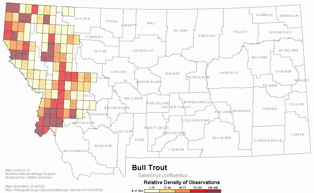
The motives for the dam removal are directly tied to the tailings deposited at its base. In 1981, arsenic was found in Milltown groundwater. It had infiltrated from the tailings deposit, and posed a human health risk via residents wells used for drinking water. The dam also was problematic for fish, particularly bull trout, listed as a federally threatened species in 1998, as it blocked significant migratory routes from the Lower to Upper Clark Fork, and the reservoir behind the dam created prime habitat for non-native, predatory pike. There were also concerns that the dam was old and decaying, fears that were magnified by an ice jam event near the dam in the mid 1990’s. Compounded, these reasons added up to the ongoing dam removal.

And last month’s breach was only a part of the overall restoration of not only the dam site, but the entire Clark Fork Basin. Upstream, the restoration of Silver Bow Creek continues. The Opportunity site, formerly known as the ponds, now affectionately referred to as the BP-Arco Waste Repository, looms, and we are left to watch and wait and hope that sprouts will appear in the new layer of Milltown sediment. Across I-90 from Opportunity, the Warm Springs Ponds, where lime is added to the waters of Silver Bow Creek to reduce its acidity and cause heavy metals to drop out, remain a question mark. In the short term, the ponds have become excellent waterfowl habitat, but the future of that site, like so much of the Clark Fork, is unclear.

In other words, restoration is not a one-day celebration. The dam breach, while certainly a pivotal moment in the history of the basin, is only a small step toward a healthy river system, toward undoing the damages a century of careless progress wrought. We are all culpable for those damages, so long as we continue to enjoy electricity, and we all share part of the moral obligation to preserve and restore this high wild river basin. And, make no mistake about it, restoration is no simple matter. It will take money and hard work to return the Clark Fork to a healthy ecosystem, and, more than anything, it will take time.

The crowd that came out for the dam breach greeted the free-flowing waters of the Clark Fork and the Blackfoot with cheers and rapt attention. It was inspirational to see so many so invested in the restoration. If the restoration of the Clark Fork, America’s largest Superfund site, is to succeed, then we must maintain our focus and our respect for these wild places, and make those values a foundation of our Montana culture. The dam breach is a good start. We should take strength from it. There is still much work to be done.