Monday, March 8, 2010

The EPA Take a Look Back at the
Last 5 Years of Butte-Area Clean-Up

Officials from the Environmental Protection Agency and its consultants from CDM, are in the midst of a mandated Five-Year Review of Superfund sites stretching from the city of Butte down Silver Bow Creek as far as the Warm Springs Ponds. The review is a regular checkup on a Superfund site to ensure that clean-up decisions continue to protect people and the environment. Given the number of environmental issues at play in the Butte area, from capped mine dumps on the Butte Hill to signs of recontamination in Silver Bow Creek to the still-untouched West Side Soils area, the review committee will be busy. The review is expected to be completed by September 2010.

In addition to talking with on-site workers and local officials, the review committee is also interviewing Butte citizens to get their take on how environmental clean-up efforts in the area have succeeded or fallen short. The Citizens Technical Environmental Committee (CTEC), Butte's EPA-funded and citizen-led community Technical Assistance Group, recently held two public meetings on February 24 and March 3 to provide the public with information about the Five-Year Review process, the status of Butte-area Superfund sites, and to collect comments from the public.

At the Feb. 24 meeting at the Butte Public Library, Dr. John Ray, a Montana Tech Liberal Studies Professor, discussed what is known as the Butte Priority Soils Superfund site, which includes the urban areas of Uptown Butte. Contamination a the site includes historic mine waste, mine tailings, and residential soils and dust related to the area's mining history. Contaminants of concern include heavy metals such as lead and mercury and other toxins such as arsenic.

Ray was highly critical of EPA-led clean-up efforts in this area. Ray stated that the EPA decision to leave the "waste in place" by capping rather than removing mine waste has resulted in capped dumps that require ongoing maintenance to prevent the failure of the caps and the exposure of waste. Because of the urban nature of the area, exposed mine waste could potentially impact human health. According to Ray, the majority of mine dump caps have failed. Capping generally involves covering exposed mine waste with 18 inches of topsoil that is then seeded and monitored for erosion issues. Butte-Silver Bow county annually evaluates and repairs these caps, with the expenses paid by ARCO, the EPA mandated responsible party for the site.

Ray also criticized the EPA decision to fence-off or otherwise restrict access to many environmentally damaged sites in the Uptown, preventing local residents from accessing such areas and being exposed to wastes. Ray particularly emphasized environmental justice as an important component of any Butte clean-up, noting that the majority of those living in the Superfund area fall below the poverty line or have below-average income. Ray noted that the EPA has a mandate to consider environmental justice. EPA personnel on hand at the meeting did not agree with Ray's assessment of environmental clean-up on the Butte Hill.

(Photo above shows a capped Butte mine dump in the foreground as evaluators assess the site, and in the background uncapped mine dumps can be seen behind the fence of the Mountain Con mine yard.)

At the same meeting, Ian MacGruder, a consultant from Kirk Environmental working with CTEC, delivered a presentation about the clean-up of Silver Bow Creek, the Warm Springs Ponds, and the Westside Soils, an area to the north and west of Uptown Butte that is listed as a Superfund site due to the presence of numerous mine dumps. No action has been taken at the Westside Soils site to date. EPA considered it a low-priority because no people live in the area, though it is popular for recreation.

MacGruder discussed the success of the Silver Bow Creek restoration, which was led by the State Department of Environmental Quality in conjunction with EPA. That project has been largely successful in removing historic mine wastes from the creek bed and floodplain. The ecosystem seems to be on the road to recovery, and brook, rainbow and native west slope cutthroat trout have been reported during Fish, Wildlife and Parks annual electrofish monitoring of the once-decimated creek. Restoration of the creek is still ongoing in the Anaconda and Durant Canyon areas. (Photo above shows historic tailings deposits on Silver Bow Creek. This site, near Miles Crossing and Durant Canyon, has since been restored; the tailings pictured here now reside in the Opportunity Ponds, aka BP-ARCO Waste Repository.)

Removed Silver Bow Creek wastes are transferred by rail to the Opportunity Ponds, also known as the BP-Arco Waste Repository. The Repository, a former tailings pond for the Anaconda Reduction Works and Washoe Smelter, already holds millions of tons of historic wastes, and wastes removed from Silver Bow Creek and the Milltown site near Missoula have been transferred there, increasing the total volume of waste at the site by a few percent. (Photo above shows an aerial view of the Opportunity Ponds site, which is roughly 5 square miles. In some places, mine wastes are 40+ feet deep. The yellow color comes from the tailings themselves; they are toxic to vegetation, so few plants grow, although revegetation efforts are ongoing at the site.)

Recent data has shown that some contaminants from the Butte Hill in the form of sediments are reaching the restored Silver Bow Creek. It is likely that additional action on the Butte Hill and continued monitoring and management of contaminated Butte groundwater will alleviate this recontamination in the future. For the time being, contaminants mainly flush down the restored reach of the creek to the Warm Springs Ponds.

The Warm Springs Ponds, another former Anaconda Company waste management site, were created to capture contaminants from Silver Bow Creek, preventing them from reaching the Clark Fork River. The site has been extremely successful in that regard, and has also become an excellent habitat for waterfowl and abnormally large trout. Future plans for the management of the Warm Springs Ponds, however, are somewhat murky. There is also a lingering arsenic issue at the ponds; lime is added to Silver Bow Creek water to cause metals present in the water to settle out in the ponds by reducing the acidity of the water. This reduction in acidity has the unfortunate side effect of mobilizing arsenic, and data indicates that arsenic levels flowing out of the ponds into the Clark Fork River are higher than expected. As long as no one drinks from the Clark Fork, this should have little effect on human health, although the arsenic issue will have to be addressed in the future.

EPA Remedial Project Manager Roger Hoogerheide responded to the presentations by noting that, while in the past the Five-Year Review process has been something of a rubber-stamp formality, the current EPA administration has instructed agency personnel to treat the Five-Year Review seriously and thoroughly as a means to improve ongoing clean-up efforts.

When asked about the relative scarcity of discussions of the Five-Year Review in local media, Hoogerheide agreed that there was more the EPA could do to inform and involve the community. The ongoing citizen interviews are a large part of the EPA's increased public relations efforts on this Five-Year Review.

The Mar. 3 meeting at the Butte Chamber Visitors Center featured the same presentations, although for this meeting the Silver Bow Creek/Warm Springs Ponds presentation was delivered by Montana Tech Society and Technology Professor Pat Munday. The community discussion was somewhat more lively at this meeting. Most citizens present expressing frustration with the pace of Butte-area clean-up and the difficulty in finding answers to Superfund-related questions and in participating in area Superfund-related programs like the Multi-Pathway Residential Metals Abatement Program Plan. That program is designed to mitigate potentially harmful exposure of residents to sources of lead, arsenic, and mercury contamination. EPA personnel at the meeting again expressed a renewed commitment to public outreach to ensure that local residents are connected to and informed about ongoing clean-up efforts.

Local citizens are encouraged to comment on the clean-up of the Butte environment. Written comments can be mailed to:
Roger Hoogerheide
Remedial Project Manager EPA Montana Office
10 W. 15th St.
Helena, MT 59626

For more information on the Five-Year Review, call Wendy Thomi, EPA Community Involvement Coordinator, toll free at 1-866-457-2690

(Photo above shows historic mining and smelting in the city of Butte, which accounts for the contamination we see and manage today.)

Tuesday, February 23, 2010

Milltown, Montana: Film Creates a Cultural Portrait of Western Montana

If a picture is worth a thousand words, a moving picture must be worth considerably more. Judging by his latest work, I believe Rainer Komers must have taken that old adage to heart. His film Milltown, Montana takes the motion picture genre on a journey of “poetic minimalism”. What this meant became clear to me when I spoke with Rainer prior to the screening, and he mentioned that the film had no dialogue and no score. Considering my minimal exposure to "avant-garde" film, I couldn't help but be skeptical. The screening at Montana Tech attracted an audience of about 50 people, quite a few more than I was expecting.

What I noticed as I watched the film is how little I missed the traditional narration and accompanying soundtrack. Komers captures these “acoustic soundscapes” to go along with the visuals, which are greatly enhanced by his considerable acumen behind the camera thanks to his years of experience as a cinematographer. The sounds are vivid enough to capture your attention, with an abstract musicality that can be hypnotizing at times.

I found that the absence of a narrator allowed the viewer to become an impartial observer, free to draw their own conclusions as to the meaning of what they were seeing. Some of the sights I recognized throughout the film were shots of the M&M sign, The Legion Oasis, the Clark Fork Watershed, the State Prison and various snapshots of everyday life in the region. There was a billiards scene in the Legion that garnered quite a few laughs, an injection of humor I wasn't quite expecting.

In another review of the film in the Missoulian, the author seemed very upset that the film did not tell the story of Milltown in particular. As Komers explained to the audience during the Q&A session, the title is meant to be generic, to describe any region that has been through the growing pains of the industrial age. He explained this by relating a tale of coal mining in his native Germany, where the towns have similar problems with pollution and mining. My personal interpretation was that the film seemed like it was intended to be a snapshot in time, a cultural portrait with minimal bias. The film was only 30 minutes long, but managed to capture the essence of many aspects of life in Montana in that short time.

The region around Butte has the distinct privilege of having two films made about it in a short period of time. Milltown, Montana may not have the historical scope of the much acclaimed Butte, America, but it offers a more intimate portrayal of everyday life in post-industrial Montana. The two films compliment each other, one telling the story of the past, the other showing how residents deal with the repercussions of that past, from an outsiders perspective. Komers has a talent for being the outside observer, presenting a way of life without the usual editorial spin. I would consider Montana lucky to be included in his impressive body of work.

For a complete listing of Komers film work, visit: http://www.imdb.com/name/nm0464624/

-Guest Blog by Aaron Briggs
Montana Tech Professional & Technical Communications Student

Monday, February 22, 2010

U.S. Fish and Wildlife Service Examines Bull Trout Habitat

The bull trout is one of Montana’s most unique fish. They can grow to over three feet and can weigh over 20 pounds, and depend on cold, clear water. Bull trout are excellent indicators of water quality, and are often considered an “umbrella” species. That is, if water quality is healthy enough for bull trout, it is likely healthy enough for most other, less-sensitive aquatic species native to Montana. Their sensitivity to adverse water conditions, coupled with the competition posed by non-native fish such as the brook trout, have caused bull trout numbers to slowly decline across the northwest, and they were listed as a threatened species under the Endangered Species Act (ESA) in 1998.


On January 13, the U.S. Fish and Wildlife Service proposed to revise its 2005 designation of critical habitat for the bull trout. Under the ESA, critical habitat identifies geographic areas essential for the conservation of a listed species. Critical habitat designations provide extra regulatory protection to areas that may require special management considerations, and the habitats are then prioritized for recovery actions. The critical habitat designation does not affect land ownership, does not allow government or public access to private lands, and does not impose restrictions on non-federal lands unless federal funds, permits or activities are involved. However, it alerts landowners that these areas are important to the recovery of the species. In the Clark Fork Basin, as restoration continues on mining-impacted ecosystems, maintaining quality bull trout habitat can be seen as a final hurdle; if bull trout return to some of the historically damaged areas of the Clark Fork watershed, then we can safely assume that restoration efforts are succeeding.

In total, the Service proposes to designate approximately 22,679 miles of streams and 533,426 acres of lakes and reservoirs in Idaho, Oregon, Washington, Montana and Nevada as critical habitat for the wide-ranging bull trout. The proposed revision comes after extensive review of earlier critical habitat proposals and public comments. The Service voluntarily embarked on this re-examination to ensure that the best science was used to identify the features and areas essential to the conservation of the species.

In Montana, additional bull trout critical habitat is proposed for the Kootenai, Clark Fork and St. Mary River Basins. Under the 2010 proposal, most tributaries of the Blackfoot River, Flint Creek and the Clark Fork River would be considered critical bull trout habitat. Most of the Blackfoot, as well as sections of Flint Creek and the Clark Fork, were previously designated as critical bull trout habitat in 2005.

The Clark Fork and Flathead watersheds were historically important to bull trout prior to the heavy impacts caused by human developments such as hydroelectric dams, other manmade barriers, and historic mining. Today, those river systems are being reconnected through dam removal (Milltown Dam), improved fish passage (Cabinet Gorge, Noxon Rapids, Thompson Falls), and improved habitat (Clark Fork restoration projects). The Clark Fork River is particularly important, as it provides a migratory corridor for bull trout from Lake Pend Oreille and the lower river to access the Blackfoot, Rock Creek, and potentially Flint and Warm Springs Creeks, where significant populations of bull trout remain.

To do our part to help bull trout recover, anyone fishing in western Montana should repeat the mantra: No Black, Put It Back! Bull trout are most easily distinguished from other Montana trout by their top fin; unlike other trout, the bull trout have no black spots on their top fin. They are also characterized by a slightly forked tail and pale yellow, orange and red spots on the body. As a threatened species, bull trout should be released immediately if caught. To assist in identifying Montana trout, CFWEP, Montana Fish Wildlife & Parks, the Sierra Club, and the University of Montana distribute free pocket fish ID guides. Contact CFWEP for your free guide before heading out on the river.

The Service will accept public comments on the proposed critical habitat until March 15, 2010. For information on how to submit a public comment, and for more on the proposed critical habitat designation, visit www.fws.gov/pacific/bulltrout. For a direct link to a map comparing existing bull trout critical habitat with proposed 2010 habitat, click here. You can learn more about bull trout in Montana at the Montana Field Guide from mt.gov.


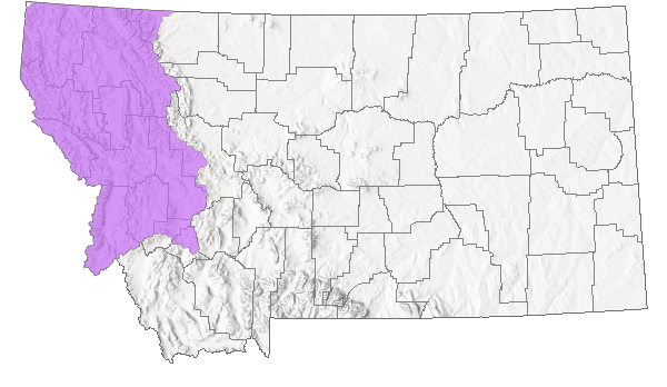
The above map shows bull trout range in Montana.

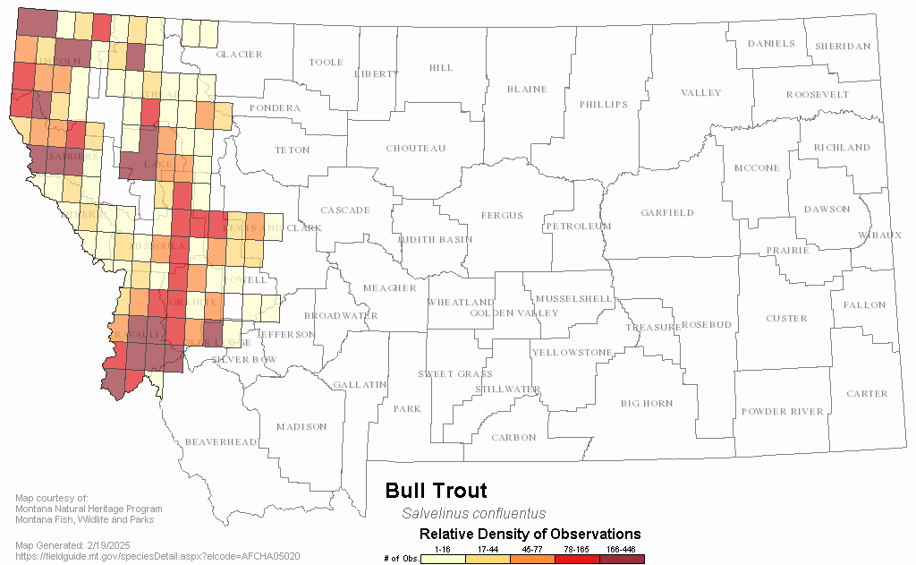
The above map shows bull trout density in Montana.

Wednesday, February 10, 2010

Volunteers Needed for 2010 Spring Field Season

CFWEP is seeking volunteers for spring field trips running from March 2 through June 1, 2010. Volunteers provide support on field trips with middle and high school students and teachers. Volunteering requires no previous experience (CFWEP will provide field science training), it is a great way to learn about the Montana outdoors and the restoration of the Clark Fork Basin, and you will be helping future generations to become stewards of western Montana's amazing environment.

For a complete list of spring volunteer opportunities, click here to view the full schedule (MS Excel format). To register as a volunteer, or to learn more, contact CFWEP Field Coordinator Dr. Arlene Alvarado at aalvarado@mtech.edu or call (406) 496-4862.

Thursday, December 3, 2009

CFWEP Dives into 4-H Fun Day in Deer Lodge

On Thursday, October 15, over 60 students from seven Montana counties convened at Powell County High School in Deer Lodge for the annual 4-H Fun Day, and Lorna McIntyre and Matt Vincent were on hand to bring kids face-to-face with some of Montana’s water bugs. The Fun Day also offered classes on Hemp Necklaces, Dutch Oven Cooking, Let’s Look for Birds, Gold Panning, and No Bake Treats.

At the CFWEP class, kids of varying ages collected water bugs from Cottonwood Creek, a tributary of the Clark Fork River that flows into Deer Lodge from the Flint Mountains. Matt chatted with the kids about how scientists use aquatic insects as an indicator of stream health. After that, students put on rubber boots and headed to the creek to explore the different sampling methods used to collect the “macroinvertebrates”, or macros, as they are known is scientific circles.

The students’ ability to notice differences in macro morphology, or physical appearance, is the first step in understanding biological diversity. They identified many different types of aquatic macroinvertebrates, such as mayflies, stoneflies, caddisflies and even planaria, a type of flatworm that can be tricky to properly identify.

The kids came away with a better understanding of the concept of biological diversity, and they had a blast finding and categorizing some of Montana’s smaller wildlife.

-Lorna McIntyre

Tuesday, November 24, 2009

Big Day on the Big Hole River

Photo Above: Dr. Michelle Anderson helps students use scientific tests to assess the water quality of the Big Hole River.
On Wednesday, October 21, 2009, the Big Hole Watershed had its first Big Hole River Youth Field Day. Jami Murdoch, the Big Hole River Foundation’s Outreach Coordinator, and CFWEP co-organized the event, introducing the students of the Big Hole Valley to water education by sharing hands-on, place-based, scientific knowledge of their watershed.

Throughout the day, students traveled through six stations. Each station’s focus had a direct connection to the Big Hole. In “A River Runs Through It”, students took a hand in mapping their watershed as they explored the run of the Big Hole River and its tributaries.

At “The Grass Isn’t Always Greener”, students learned the importance of a diverse plant community and the effect of noxious weed to the watershed. “What is ‘High Quality H2O’?” found students, assisted by Dr. Michelle Anderson from UM-Western, performing sophisticated scientific tests on water samples from the river to determine what water quality parameters are necessary for a healthy river.

At “A Bug’s World”, students interacted with aquatic insects to learn the importance of the variety of stream bugs in the river. The station also tied into the Big Hole River’s salmonfly hatch that draws anglers from around the globe, an important source of money for the local economy.

“Something Fishy” focused on the different fish of the Big Hole, particularly the fluvial, or river-dwelling, arctic grayling, whose numbers have dwindled in recent decades. Finally, at the charmingly titled “I Eat, Therefore I Puke”, Dr. Amy Kuenzi from Montana Tech helped students investigate one of the Big Hole’s avian residents, the owl, and its need for mature cottonwood forest to provide habitat for the critters it eats.

Photo Above: Students learn about the types of food on the menu for owls with assistance from Dr. Amy Kuenzi.

The Big Hole Youth Field Day was only possible thanks to the immense support of a dedicated group of volunteers from around western Montana. A special thanks goes out to Insty Prints of Butte, who gave us a sweet deal on the Big Hole River Watershed Passports used for this event.

-Lorna McIntyre

Monday, November 23, 2009

Mining the Highlands


While Montana’s wide-open mountain vistas, relatively undisturbed wildlife habitat and peaceful, windy quietude have risen among the top of the state’s golden treasures, there is still plenty of interest in the kind of gold currently fetching over $1,000 per ounce on the worldwide metals market. Just 15 miles south of Butte in the heart of the Highlands Mountains, Timberline Resources is making way for a new, 750,000+ ounce underground gold mine. The Idaho-based newcomer to the mining industry began laying the groundwork in August for what the corporation hopes to be a 10-year project that could employ up to 100 workers. Timberline stock (TLR) began trading on the NYSE back in May and has sold just shy of 36 million shares of its 44.5 million cap, trading most recently at $1.24.

So how does a mine that could employ 100 people and that has sold over 35 million shares on Wall Street go relatively unheard of in a mining community of 30,000 people just miles away? Timberline began working in August and has been progressively forging ahead ever since under an amended exploration permit and a small mine exemption, both granted by the Montana Department of Environmental Quality’s Hard Rock Mining division. Neither of these processes require an official public comment period or a full-scale environmental impact study. Timberline presented the project to the Butte-Silver Bow Council of Commissioners in May and most recently in October at the National Summit of Mining Communities in Butte.


This project has a lot of costs and benefits for The Mining City and the surrounding areas that will need to be weighed by our citizens prior to the commencement of full-scale operation, as awakening community awareness has just recently begun to pique public interest. According to Timberline’s website (http://www.timberline-resources.com/) the mine properties consist of approximately 1,100 privately-owned acres situated along the Continental Divide at the headwaters of Basin (Upper Clark Fork Watershed/Butte drinking water supply), Fish (Jefferson River Watershed) and Moose (Big Hole River Watershed) Creeks. Under the current exploration and small mine development permits, approximately 50 acres will be disturbed at the site, over one-mile of underground tunnel dug and a 10,000 ton “bulk sample” collected over the next year. The ore is approximately 0.27 ounces of gold per ton. For more information, visit the Timberline Resources website above, or contact Robert Crohnholm with the DEQ at (406) 444-4330.

-Matt Vincent